Alternatives
There are other systems already active and gaining popularity. Here we discuss the ones we know about and highlight why we think SpotReg is a better solution.
What3Words
Website: What 3 Words
What3Words provides you with 3 words that represent a 3m x 3m square for the location you're in. Using their software you can convert these three words back into Latitude and Longitude. They have a proprietary database that says which words represent which geographical spot. If you move a few metres the three words completely change. For example, you might be standing in glows.bland.haggis and move a fraction and be in info.coverings.tokens
We think SpotReg improves on What 3 Words because:
Words can be long
Words in What 3 Words can be up to 18 characters long. Can you spell environmentalists? or unenthusiastically? SpotReg has a maximum word length of 9. To be able to map all 3m squares on the planet in just 3 words you need a dictionary of 17,000 words in each slot. That means it's unavoidable to have to use long words, plurals and singlulars, negative words and so on.
No Sentence Patterns
SpotReg uses sentence patterns to make the words sound funny and hence easier to remember. What 3 Words does not.
Words Can Repeat
SpotReg uses a unique lookup dictionary for each word position. There are no common words between the dictionaries so you can never get the words the wrong way round. You could potentially have unenthusiastically.unenthusiastically. unenthusiastically in What3Words
Not Hierarchical
What 3 Words is not hierarchical. This means that in our example, glows.bland does not contain glows.bland.haggis. Even if it did, it would only allow for 3 levels of hierarchy. A SpotReg gets more and more precise the deeper you go, with each level containing all the SpotRegs below it. This is very useful because if you are travelling to an area represented by a SpotReg, you can tell that you are getting near because the SpotReg will be roughly right. Also, it's likely that your neighbours will have similar SpotRegs which means if a delivery person manages to find one of your neighbours, they will probably be able to find you too (without needing additional interaction with an app)
There is no code
The What 3 Words relate directly to latitude and longitude. SpotReg is more about the code or 'postcode alternative' which is great for storing in databases, and of course you can use the words for talking and remembering.
Anyone Can Use the SpotReg Functions
The functions for generating SpotRegs, both the codes and words, and getting the latitude and longitude back are small and easy to incorporate in any system.
Google Plus Codes
Website: Plus Codes
Plus codes are very similar to SpotReg codes and do the same thing - they are a way of translating between latitude and longitude and a code. There is no word look-up scheme though.
The algorithm to calculate a Plus Code has the following differences:
The SpotReg algorithm recursively and evenly divides the map up into a 5x5 grid.
The Plus Code algorithm recursively divides the map up into a 20x20 grid choosing 2 characters at a time, one representing the latitude and one representing the longitude until you reach 10 characters, then it switches to choosing one character from a 4x5 grid the same way SpotReg chooses from a 5x5 grid. For the 20x20 grid part it means that there are always 2 characters chosen at a time.
The initial 10 character code is split up into two parts. The first part is 4 characters long and represents an area code.
The second part is a combination of 4 characters, a plus sign (hence the name Plus Codes) and 2 more characters.
5GPCHC84+H4
This technique ensures that neighbouring codes always only differ by 1 character in either of the x or y directions.
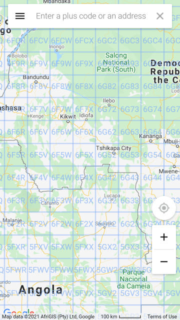
The problem though is that it does not zoom well when moving in and out of the map. On a phone you can't even see the Plus Code in some places:
Google Plus Codes not visible
SpotReg codes visible at any depth
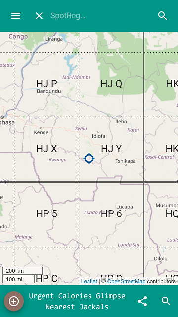
And the next zoom level is too overcrowded:
Google Plus Codes overcrowded
SpotReg codes nicely visible
We think the better zooming functionality of SpotReg beats the better neighbouring functionality of Plus Codes, not to mention SpotReg has an additional layer of words to make them easy to communicate.
Map.gov.zm
Website: map.gov.zm
The approach taken by the Zambian NSDI is to carefully map the outline of all plots in lusaka (and the rest of Zambia?) and give each plot a code. The code can then be used to look up the plot using a database query. This is great if you want to look up the boundary of a plot. The information also conveys 'ownership' but is not really what delivery companies need. A plot could represent many acres. Where should the delivery company arrive at? We believe SpotReg can happily sit in tandem with this system, offering one or more pin point delivery locations for each plot.
Also:
- Capturing the plot outline is a super-labour-intensive process.
- Requires the ongoing expense of keeping a database server up and running along with serving the specialised map overlays.
- The map display is based on a bitmap and this was captured several years ago. This means it is out of date and difficult to update.
- It is hard to see the codes given to the plots, and they are only visible at high zoom levels. (The codes are not Hierarchical)
- The website is not secure (doesn't use https)
- The website is often down.
- It looks old and in need of some modernisation.
Whereas SpotReg:
- No labour required - the whole world is automatically available.
- Minimal server costs - no database required, no web server, no server-side map overlays.
- SpotReg is all about deliveries and meeting up - all the delivery company needs to know is where is the gate?
- There is 'anonimity' in SpotReg that users may prefer. Other systems may tie together people with SpotRegs but SpotReg itself doesn't.
- A SpotReg code can be as precise or broad as wanted and this allows us to zoom in and out and see the precision change.
- A SpotReg can identify anything, not just plots.
- The website is fast and modern and easy to extend.
SnooCODEs
Website: SnooCODEs
SnooCODEs, like Google Plus codes are very similar to SpotReg codes and do the same thing - they are a way of translating between latitude and longitude and a code. There is no word look-up scheme though. The SnooCODEs are shorter than a SpotReg. How does it manage this?
The codes are only unique to a region, so there can be many locations on the planet with the same code. This means that to fully identify a location you need to know both the region and the code. This makes storing a SnooCODE in a database a little tricky, and also displaying codes on the map can only be done once the region is known - so you can't zoom in from the top. In fact the SnooCODE system does not display codes on the map at all, so you are completely reliant on your GPS working properly. With SpotReg you can visually search and see SpotRegs on the map as you move the map around.
The character set used to create snoo codes includes 1s and Is (the number one and the letter I). These can look the same.
The SnooCODE system is a paid-for service when used in a non-personal manner.
The SnooCODE system adds additional features like 'Directions', 'finding a taxi' and so on. SpotReg does not attempt to get involved with any additional services, the reason being that these are already handled well by other suppliers and SpotReg purely focuses on one thing and tries to get that one thing right. SpotReg passes locations through to the apps that provide these services.
The SnooCODE system only runs on devices like Android and iOS phones and tablets. SpotReg is web-based so runs on anything.